About
Why We Are Doing This Work
In 2015, City Council approved the Riel Industrial Sector Plan (Sector Plan) that provides a broad framework for future urban development in the area. This includes, among other things, direction on land uses, parks and significant natural areas, servicing and transportation planning, and development phasing.
Since 2015, several City policies, bylaws, and plans have changed or been approved. To ensure development in the sector aligns with the City’s vision for growth and development, an amendment to the Sector Plan is needed. City Administration introduced the Riel Industrial Sector Plan Amendment project through an Information Report to the City’s Standing Policy Committee on Planning, Development and Community Services (PDCS) on August 9, 2023. City Administration intends to bring forward the Sector Plan amendment for City Council’s consideration in 2026.
What are sector plans?
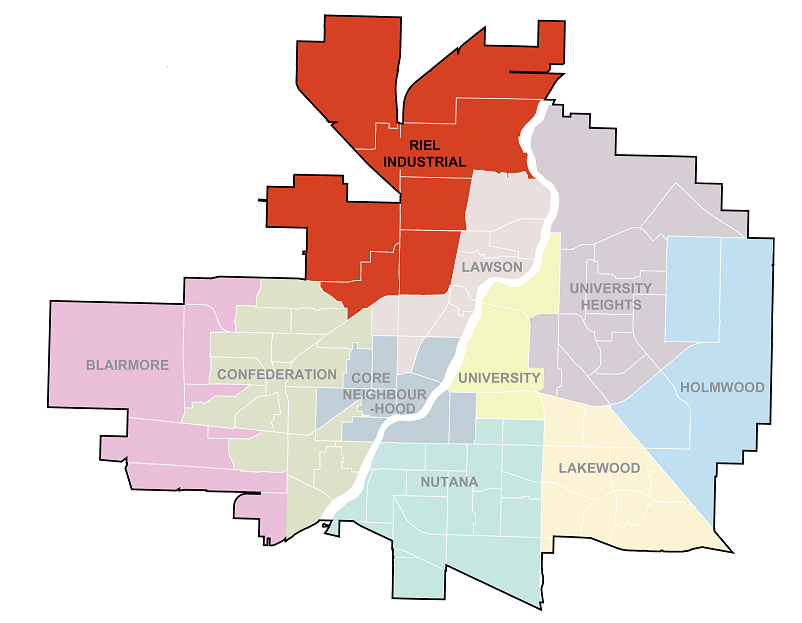
Saskatoon is divided into sectors (see the figure below). Each sector is typically made up of six to ten neighbourhoods, creating areas that accommodate approximately 50,000 to 80,000 people. Unlike most sectors, the Riel Industrial Sector is comprised of employment areas. These Employment areas provide jobs, goods, and services for Saskatoon and the surrounding region.
To manage growth efficiently, a sector plan study is completed to create the overlying vision for each sector. Sector plans provide a broad framework for future urban development, including the location and size of future neighbourhoods and employment areas, major parks, and significant natural areas.
Sector Plans have three main purposes:
- To apply the vision for Saskatoon, as outlined in the Official Community Plan to an individual sector.
- To provide a framework for development of future employment areas via concept plans to ensure growth is balanced, compact, and connected to established areas.
- To identify key land uses, environment and open space, servicing, and transportation needs that will be further refined through the concept plan process.
Sector plans are high level, preliminary planning studies and are future oriented. The timeframes for a sector’s development are largely dependent on market conditions and availability of servicing. Sector plans provide guidance on the phasing of development but not the timeline.
.jpg)
What is the Riel Industrial Sector?
The Riel Industrial Sector is located in north Saskatoon and includes approximately 4,496 hectares (11,110 acres) of developed and future employment areas, accounting for 19% of Saskatoon’s total area. The Riel Industrial Sector is an ideal location for future industrial and commercial employment growth due to its proximity to highways, railways, Saskatoon Airport, other existing industrial areas, and potential workforce within Saskatoon and the surrounding region.
The Riel Industrial Sector represents over 80 years of employment area development. The Sector’s developed employment areas include North Industrial, Airport Business Area, Airport Management Area, Hudson Bay Industrial, Agriplace, and Marquis Industrial. The Sector’s future employment areas include the North Development Area and Northwest Development Area.
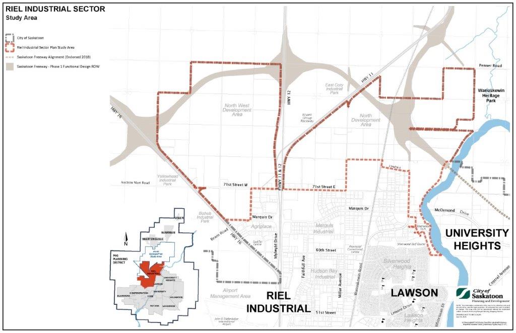
What is the Riel Industrial Sector Plan amendment study area?
The study area for the Riel Industrial Sector Plan Amendment project focuses mainly on undeveloped portions of the North West Development Area and North Development Area, as well as some existing development in those areas and Marquis Industrial. The study area comprises approximately 1,908 hectares (4,715 acres) and is divided by Highways 11 and 12.
The west side of the study area includes the North West Development Area, bordered by Highway 16, future Saskatoon Freeway, Highway 12, 71st Street West, and north extent of Agriplace. The east side of the study area includes the North Development Area and a portion of Marquis Industrial, bordered by Highway 11, Saskatoon Freeway, Penner Road, Wanuskewin Heritage Park, the South Saskatchewan River, Silverwood Golf Course, Wanuskewin Road, north extent of Marquis Industrial, and 71st Street East. Both sides of the study area are connected by 71st Street.
Why is the amendment necessary?
City Administration is currently undertaking an amendment to the Riel Industrial Sector Plan to:
- Integrate the direction(s) from the Province of Saskatchewan’s Saskatoon Freeway Phase 1 functional study.
- Update the Riel Industrial Sector Plan development framework via updated land use, environment/open space, utility infrastructure, and transportation planning, including development phasing.
- Incorporate the recommendations from the recently completed Natural Area Screening study and Market Study, and other studies that are planned or underway, including the City's North Saskatoon Network Planning Study and Industrial-Residential Interface Study.
- Incorporate potential changes resulting from planned or pending development involving Indigenous land interests, which may include First Nations and Métis communities as well as other Indigenous organizations.
- Incorporate considerations related to Wanuskewin Heritage Park’s pending application for UNESCO World Heritage Site status.
- Incorporate considerations related to Meewasin’s potential National Urban Park designation.
- Ensure the Riel Industrial Sector Plan aligns with changes to The Official Community Plan Bylaw, 2020 and other relevant updates to City bylaws, policies, plans, and initiatives.
- Ensure the Riel Industrial Sector Plan aligns with relevant regional planning work, including P4G District Official Community Plan, District Zoning Bylaw, and North Concept Plan.
What is the vision for the Riel Industrial Sector Plan amendment study area?
The vision for the Riel Industrial Sector Plan amendment study area is to facilitate economic development opportunities by expanding the City’s north employment area. Development of the Riel Industrial Sector is expected to:
- Accommodate a wide range of industrial development in an efficient, economical, and sustainable manner.
- Provide new jobs, goods, and services to the City and surrounding region.
- Promote active and multimodal transportation options, including personal vehicles, public transit, cycling, and walking.
- Accommodate efficient movement of goods by trucking, rail, and airline industries.